
The tragic events of last summer confirmed that floods are among the most costly and dangerous natural disasters Australians face.
Our response must start with a thorough examination of how we can better predict flood events and assess risk. And first we must tackle the uncomfortable question of whether it’s appropriate for people to live on flood plains in the first place.
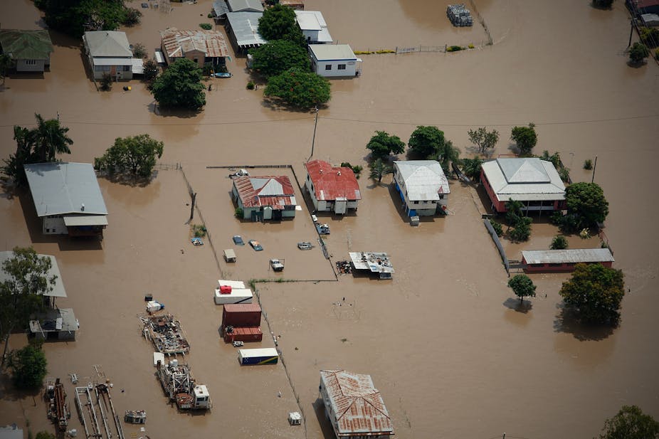
People have used flood plains for millennia. Highly fertile soils result from sediments brought by past floods and proximity to rivers provides water as well as transport and energy, and attracts game.
As a result, many of our farms and towns are on floodplains. The farms make sense, the cities and towns don’t, at least to the extent that expensive capital is located in places we know will be regularly flooded.
Physical engineering options such as dams and levee banks can protect floodplains to some degree. But they are limited in that they can never protect against all floods and are often expensive. They can also have impacts on the environment and the river system. Patterns of flow are changed, migration routes are broken, flows of sediment are interrupted, which causes channel erosion.
Most flood mitigation measures also increase flood levels or durations either downstream, immediately upstream, in areas not protected by levees or in the areas affected by dam impoundments, making flooding worse elsewhere.
When levees and embankments are overtopped or fail, they generate new problems by trapping water, as seen in some parts of Victoria at present. Flood mitigation also deprives flood plains of an important source of fertility in the long term.
Usually the cheapest and safest option for dealing with floods is to make sensible decisions about land use on flood plains. Serious consideration needs to be given to expanding buy-back schemes, such as those implemented by Brisbane City Council which has offered over recent years to buy houses likely to be flooded in 50% of years.
This enables people with flood-prone properties who may otherwise be financially locked into their situation to move out and for the landuse to be changed. This can avoid highly predictable future flood costs. It’s an initiative that deserves to be expanded.
While physical engineering options are appropriate in some circumstances where development has already occurred on flood plains, planning is a better tool. Informed engineering analysis that details where water will flood, and with what probability, can help us make better decisions.
When flooding does occur, it’s important that predictions are reliable. During the flood crisis, forecasters at the Bureau of Meteorology were working hard. But there are some unique challenges in predicting very large floods that have seen significant discrepancies in both predicted levels and timing of flood peaks.
These predictions can be improved. It’s also important that the people at risk know what to do when a flood warning is issued and have developed a response plan.
Flood forecasting depends on having prediction models developed. These models use data on past floods, how wet catchments are, rainfall across the catchment and river flows to fine-tune predictions as floods move down river systems.
The size of Australia’s recent floods meant that forecasters often had to extrapolate their predictions from experiences of smaller floods, which adds error. On the positive side the information we gather from the most recent floods will help us do a better job of predicting the next ones.
We can also improve observations of catchment wetness, rainfall and flood progression down the river systems. Some of this could be in the form of denser measurement networks on the ground – more rain gauges and river gauges with real-time reporting – but there is also scope for developing new prediction systems.
Radar and satellite data can provide important information on rainfall, inundated areas and catchment wetness. It may also be valuable to include people’s on-ground experience by utilising the internet to collect and interpret information on location of flooding in real time, for example by using GPS devices on people’s mobile phones.
Predictions and warnings for flash floods are much more challenging, yet as the tragedy in Lockyer Valley showed, its prediction is more critical from a human safety perspective.
Flash floods are local, rapidly developing events. The challenge results from a lack of observations due to their local nature and the rapidity with which warnings would need to be put out and acted upon. If we are to respond adequately and in time, we will need to forecast rainfall just hours ahead of flash flooding events.
We need to prioritise locations where flash flooding causes a high risk to people by performing systematic risk assessments in vulnerable areas. For these locations, good radar rainfall measurements, real-time reporting rain gauges, forecasting models, warning systems, response plans and infrastructure must all work together. Our response should focus on evacuation.
We have good approaches to planning and prediction that have, where implemented properly, protected our infrastructure and led us to make sensible use of floodplains.
To ensure they continue to serve us well, we need good governance over development, ensuring our civic authorities stand firm against the individual vested interests of current owners and potential developers of flood-prone land.
At a societal level, planning is the cheapest way of managing floods.