2010 was the world’s hottest year on record, with global temperatures 0.53°C above the long-term (1961-1990) average.
2011 started with a strong La Niña (perhaps the strongest since 1917), something which would normally result in global temperatures below the long-term trend. But this year is only slightly cooler than last year’s record, running about 0.1°C cooler so far. This places 2011 very close to conditions over the past decade, and reinforces that our planet continues to warm as a result of the enhanced greenhouse effect.
The warming trend over recent decades has not been uniform in time and space. Every year sees various extremes of climate, but the location of these extremes varies from year to year. Location is often influenced by El Niño, La Niña and other large-scale climate drivers (for example, an El Niño event will often result in drought in Australia, India and southern Africa, and floods on the west coast of the Americas).

Increasingly, warm extremes are outnumbering cold extremes as the influence of the background warming trend strengthens. Last northern summer, the most significant extremes were the Russian heatwave and Pakistan floods.
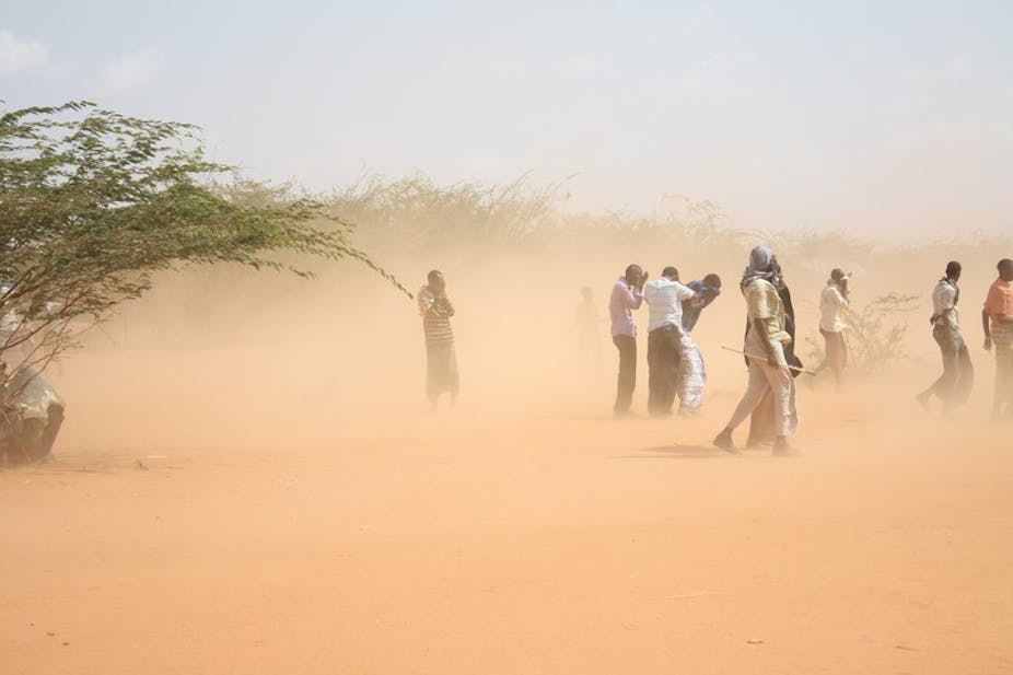
This year, while global temperatures have not reached last year’s record heights, there have been some very notable extremes in various parts of the world, including the Americas and Africa. The most significant of these events – at least in terms of human impact – has been the ongoing drought in east Africa.
East African drought
Equatorial east Africa has a somewhat unusual climate. Many tropical areas, such as northern Australia, large parts of southern and eastern Asia, or the Sahel region of west and central Africa, have a single wet season which peaks in the summer. In contrast, East Africa has two distinct wet seasons: the “long rains” from March to May, and the “short rains” in October and November. Dry conditions are the norm in between.
The current drought has focussed on a relatively small region about 600 kilometres across, covering the northeastern half of Kenya and adjacent parts of western Somalia and southern Ethiopia. In this area, after reasonable rains in the first half of 2010, rainfall was well below normal during the October/November 2010 wet season. This is quite common during a La Niña year.

However, rainfall has remained well below normal through the first half of 2011. The failure of two successive wet seasons is unusual and has played a major role in the severe food shortages in the region.
Rainfall in the northeastern half of Kenya for the past 12 months has been mostly about 50% below normal. For example, Mandera (near where Kenya, Somalia and Ethiopia meet), had about 140 millimetres in the year ending June compared to an average of 270 millimetres.
The deficits have intensified in the last few months with many parts of the region receiving less than a quarter of their usual rainfall for the March-May 2011 rainy season. Whilst no surface observations are available on the Somali side of the border, satellite data suggest that conditions there are similar to those in northeastern Kenya.

At present the drought is regarded locally as being comparable, in meteorological terms, with the droughts of 1983-84 and 1999-2000. That is, it’s among the worst of the last 60 years.
It would be highly unusual for any significant rain to fall in the region between now and the end of September, and hopes for recovery will be pinned on the next wet season, which would typically come in the months of October and November.
The drought is quite localised and west and central Africa have not been affected. Most of the Sahel region, which has suffered badly from droughts in the past, has seen near-normal rainfall so far in 2011.
American heat, drought and floods
Another region which has had more than its share of extreme weather and climate in recent months has been the United States.
For much of 2011, there has been a contrast between extreme drought in the south, and extreme wet conditions in the north.
The dry conditions have been focussed on Texas, which is experiencing the worst drought in its recorded history. Nearly all of the state, except the far south, is classified as being in exceptional drought (as are large parts of the adjacent states of Oklahoma and New Mexico). Statewide average rainfall for the year so far has been about 60% below normal, nearly 20% below the previous record. Some locations have had less than 20 millimetres rain since October 2010.

In marked contrast, spring was extremely wet in the inland northeast, as well as in Montana and the Dakotas. It was also extremely stormy with numerous destructive tornadoes: there was a record breaking count of more than 1000 in April alone.
These regions form the upper catchments of the Mississippi and Missouri rivers, and some of the most severe floods in decades have moved down the valley over the past few months – somewhat ironically, there has been major flooding in Louisiana despite the fact that Louisiana itself is having its second-driest year on record and is affected by severe drought.
In recent weeks extreme heat has also been a regular feature in the United States. Again the most extreme heat has been in Texas and Oklahoma, both of which are having their hottest summer on record, as has the broader south-central climate region. Temperatures have regularly reached the low to mid-40s.

Dallas recently ended a run of 40 consecutive days above 100°F (37.8°C), and has had five nights where the temperature failed to fall below 30°C. This had not happened even once before 2011.
Further north and east the heat has been less continuous, but almost equally extreme on occasions, with all-time record highs at places such as Newark (42.2°C), Baltimore (41.1°C) and Little Rock (45.0°C).
Over the nation as a whole, July 2011 was the fourth-warmest on record; only cool conditions in the northwest prevented more records from being set.
A notable feature of the American summer in the north-central states has been the high humidity which has accompanied the extreme heat. For example, humidity levels in the northern city of Minneapolis (at 45° north – equivalent to Dunedin in the far south of New Zealand) have reached a point as extreme as anything which has ever been recorded in Darwin.
Evaporation from large areas of standing water remaining from earlier floods has contributed to this. The copious available moisture in the northern states has allowed extreme short-period rainfalls to occur when conditions are favourable. Both Chicago (174 mm) and JFK Airport in New York (198 mm) set new all-time records for single-day rainfalls in the last month.
Is it climate change?
At the global scale, past warming now means that every year is well above the 1961-1990 average. This warming trend (estimated at around 0.15 to 0.2°C/decade) continues, and we anticipate that the record set in 2010 will likely be broken in the coming years.
The way this warming cascades through the climate system is both complex and significant, affecting the location, intensity and frequency of rain and storms, for example.
The relationship between climate change and rainfall extremes (both high and low) is complex and, in many regions, unclear. The past 15 years have been a rather dry period in east Africa but not yet to the extent that a long-term trend is obvious.
However, the dry conditions seen regularly in recent years in the southern United States parallel those in several other parts of the world at similar latitudes, notably southern Australia, parts of South America and the Mediterranean. These conditions have been linked to a poleward expansion of the subtropical high pressure zone. The United States also shows clearer evidence than many other parts of the world of an increase in the frequency of high rainfall extremes.